Import Trimble JXL
Icon: |
|
Introduction
This command supports the import of a Trimble JXL file, which is a common output format from modern Leica survey equipment. A Trimble JXL file contains attribute data, managed via Data Tables, which can be attached to COGO Points and Survey Strings as part of this command.
This command delivers two outputs:
-
The creation of COGO Points and Survey Strings, using the calculated coordinates contained in the JXL file, and/or
-
The addition of extended (attribute) data picked up in the field. This is stored in a Project Database attached to the project. Data Tables are created to support each point contained in the JXL file and data attached for each point in the JXL
This command can also be used to add attributes to COGO points and Survey Strings already included in a drawing. Users could use other methods to import points from the survey (such as use the Import and Reduce command to import the COGO Point geometry and core properties) and use this command to add additional attributes picked up in the same survey.
Attribute Data attached to COGO Points and Strings in the drawing requires the setup of a Project Database. Attribute Data is stored in a Schema which contains Data Tables. The Project Database attaches Data Tables to points and strings in the drawing, allowing data to be added and edited for each field in the attached Data Table.
Note: This commands requires the user to assign a Schema. The Import JXl-JXL schema is included with install of the software. This schema is empty (contains no Data Tables).
About Attribute Data, Data Tables and Schemas
Additional (Attribute) data can be attached to COGO Points and Survey Strings through the creation of a Project Database.
The Project Database enables the addition of Data Tables to points and strings. Data Tables contain fields of data and are contained in a Schema.
The Schema Editor can be used to create saved collections of Data Tables that can be copied into a local drawing (the Project Database). To append attribute data to points and strings, users must run the Setup Project Database command.
Details
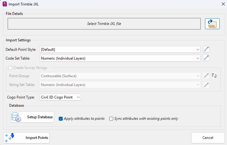
Upon selecting the command the following form is displayed:
|
|
|
|
File Details |
|
|
Select Trimble JML File |
Opens the file browser to select the Trimble JML file to import |
|
Import Settings |
|
|
Default Point Style |
Sets the point style applied to imported Cogo Points, to apply if a Code Set Table is not set |
|
Code Set Table |
Opens the Point Code Set form. |
|
Create Survey Strings (checkbox) |
Enables creation of survey strings from the imported points. When checked, the Point Group and String Set Table fields become active. If ticked on, a message will appear during import to confirm whether to create survey lines. |
|
Point Group |
Assigns imported points to a predefined Point Group (e.g., Contourable) |
|
String Set Table |
Opens the survey String Settings form |
|
Cogo Point Type |
Specifies the output Cogo Point type: Civil 3D Cogo Points or CSA Cogo Points |
|
Database |
|
|
Setup Database |
Opens the Setup Project Database form to select or set the database for the import |
|
Apply attributes to points |
If enabled, assigns attribute data (adds Data Tables) to Points imported via this command |
|
Sync attributes with existing points only |
Assigns attribute data to COGO points already included in the drawing |
|
Import Points |
Imports COGO Points and/or adds attribute data (creates Data Tables and adds data). |
|
Cancel |
Aborts the import process and closes the dialog |