Create House Corner Elevations
| Icon: |
|
| Menu: | Pipes > Create Sewer... > Auto House
Connection Tools > Create House Corner Elevations Pipes > Create Drainage... > Auto House Connection Tools > Create House Corner Elevations |
| Ribbon: | Pipes Tab > Sewer Design Panel > Auto
Connections Dropdown > Elevations Pipes Tab > Drainage Design Panel > Auto Connections Dropdown > Create House Corner Elevations |
Introduction
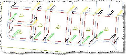
This command is used to calculate and label the elevations to all vertices (corners) of the house offset polylines to aid in the analysis of the lot elevations when creating sewer and drainage house connections. The highest and lowest corner elevations are indicated with prefixes of H and L respectively to the those elevations. These are calculated at the vertices of the house offset polylines.
Note: There may be no color differentiation on the high and low point elevation labels.
Details
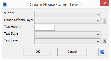
Upon selecting the command the following form is displayed:
|
|
| Surface | Select the Surface to obtain elevation information from. |
| House Offsets Layer | Select the layer the House Offsets (polylines) are drawn on.
Alternatively use  to select the layer of an object in the drawing.
All polylines on this layer will be labelled. to select the layer of an object in the drawing.
All polylines on this layer will be labelled. |
| Text Height | Specify the Text Height in model space drawing units. |
| Text Style | Specify the Text Style to be used. |
| Text Layer | Select the layer the elevation text will be created on.
Alternatively use to select the layer of an object in the drawing. |
| OK | Apply and exit. |
| Cancel | Cancel the command. |
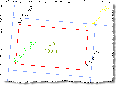
A elevation label will be created using the selected text size and style at all vertices of any polyline on the nominated layer. For each polyline, the highest and lowest elevation will be differentiated from the elevation labels created at other vertices around the house offset. The house offset polylines will be labelled similar to that shown, above.