Export to GIS
Icon: |
|
Introduction
This command exports all points in the drawing, that contain attributes, out to ESRI shape (.shp) files.
These exports include both point-based and string-based data tables, with separate files created per attribute schema. It is especially useful for GIS workflows, spatial analysis, or integration with GPS platforms. This process supports the export of data tied to custom property lists, synchronized with Cogo properties, and filtered through selected point groups
Upon selecting the command the user is prompted to select a save location for the outputs.
Outputted shape files are named based on the Attribute Table they have associated with them and the object type (Point or Line).
Details
The format of output files is as follows:
Exported_Shapefile_[Table Name]_Points for point type data and
Exported_Shapefile_[Table Name]_Strings for survey string type data
|
|
|
|
Sync to Cogo Properties |
Copies schema attributes to native Cogo point properties so they can be included in exported files. Required before exporting to ensure data is embedded |
|
Select Point Group |
Allows filtering/exporting data for specific point groups (e.g., Contourable). |
|
Setup Property List |
Opens a tool to select a predefined set of attributes (e.g., Name, Code, Role) that will be exported with each object |
|
Apply Property List |
Applies the selected property list to the points, so those fields are included in the export |
|
Export to GIS |
Launches the GIS export tool, generating .shp, .dbf, and .idx files for each attribute table (e.g., Exported_Shapefile_Tree_Points, ...Strings) |
|
Export to CAD Table |
Optionally outputs the same property data as a Civil 3D table within the drawing |
|
Choose Export Location |
Prompts the user to select a folder to save all GIS output files |
|
Separate Tables by Type |
Automatically splits data into point and string files for each schema (e.g., Tree_Points.shp, Tree_Strings.shp) |
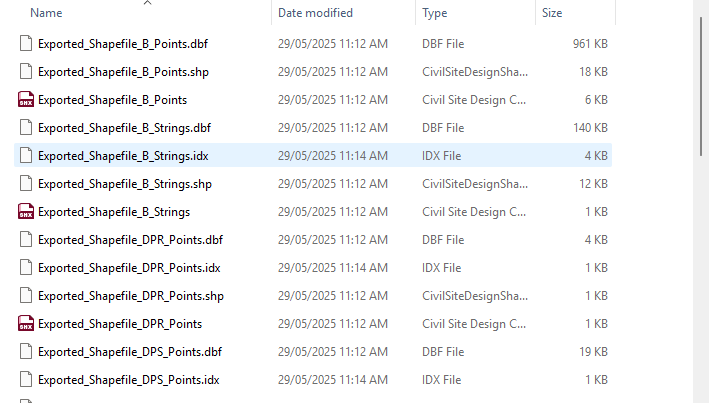
Example Output Files
The following files are typically generated after running the Export to GIS command:
| File Name | Description |
|---|---|
| Exported_Shapefile_B_Points.shp | Point geometry file for the 'B' attribute table |
| Exported_Shapefile_B_Points.dbf | Database file storing attributes for the 'B' point data |
| Exported_Shapefile_B_Strings.shp | Polyline geometry file for 'B' string data |
| Exported_Shapefile_B_Strings.dbf | Attribute database file for the 'B' strings |
| Exported_Shapefile_DPR_Points.shp | Point geometry for the 'DPR' schema |
| Exported_Shapefile_DPR_Points.dbf | Attributes associated with DPR points |
| Exported_Shapefile_DPS_Points.shp | Geometry file for 'DPS' points |
| Exported_Shapefile_DPS_Points.idx | Index file used by GIS software for fast lookup |
Each attribute table is exported as a combination of `.shp`, `.dbf`, and optionally `.idx` files depending on the data content.